The Kanawina Geopark is Australia’s most extensive, volcanic province, and has been recognized as one of the most significant in the world. The islands and coastal formations around Portland are the main volcanic features of the “coast and caves” precinct.
The geopark stretches across south western Victoria and south east South Australia, and is made up of five main precincts.
Cones & Flows Precinct
Hamilton, Penshurst, Macarther, Hawkesdale, Woolsthorpe, Caramut, Heywood, Keroit and Port Fairy.
Lakes & Craters Precinct
Colac, Camperdown, Lismore, Derrinallium, Terang, Skipton, Mortlake, Lake Bolac and Darlington.
Craters & Limestone Precinct
Mount Gambier, Millicent, Penola, Port MacDonnell, Coonawarra, Allendale East, Tantanoola, Glencoe, Nount Burr and Carpenters Rocks.
Plateaus & Falls Precinct.
Casterton, Coleraine and Hamilton.
Caves and Coast Precinct
Portland, Cape Nelson, Cape Bridgewater
Welcome to our region – Discover Australia’s most extensive volcanic province.
Australia may be referred to as a relatively young nation, but the well preserved ancient landscape provides many precious windows into the past. The Kanawinka Geotrail takes you on a surprising journey through Australia’s most extensive volcanic province with over 60 sites enabling visitors to travel back in time over thousands of years.
The Kanawinka region gets its name from the geological fault that stretches from Portland ( Victoria) to Naracoorte ( South Australia). Kanawinka is an aboriginal term meaning ” Land of Tomorrow”. The area is also internationally recognised as the Kanawinka Global Geopark.
The Kanawinka landscape of Southwest Victoria and Southeast South Australia is a striking contrast of sweeping limestone plains studded with remarkable sinkhole and caves, spectacular mountains and lava flows.
The area features nearly 400 individual eruption points, most of which occurred between 4.5 and 2 million years ago, and several hundred caves west of the Kanawinka fault.
Aboriginal people have inhabited this region for up to 45,000 years. The region features prominently in stories of the “The Dreaming” and stories from the lava flows were used by local language groups to construct channels linking the wetlands, weirs, fish traps, wind breaks and stone huts. Excellent examples created by the Gunditjmara people can be found in the Lake Conda region.
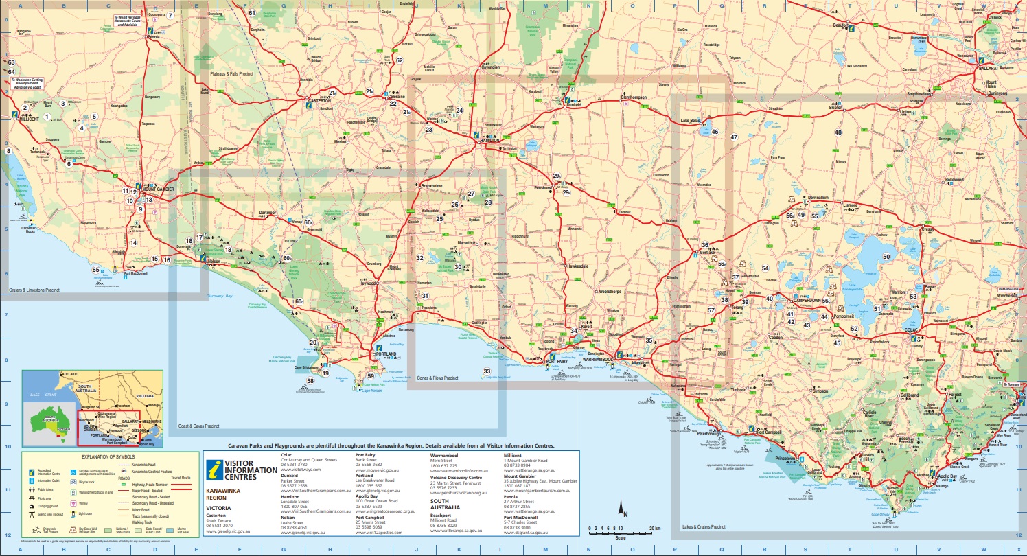
Later European settlers constructed dry stone walls in order to enclose crops and stock. Many examples can be found around Camperdown along the Dry Stone Walls Heritage Trail.
Your Kanawinka experience will take you from the Coonawarra in South Australia through to Lake Corangimite and the Great Ocean Road in Victoria and offer a range of visitor experiences including beautiful waterfalls, caves and coastal formations, and even a climb into the regions youngest volcano.
Cones and Flows Precinct

Towns of the Cones and Flows Precint include; Hamilton,Penshurst, Mscarthur. Hawkesdale, Woolsthorpe, Caramut, Heywood, Koroit, Port Fairy.
Tumuli
13 kilometres west of the Byaduk Caves are circular mounds or hummocks of rock called “Tumuli” or “Lava Blisters” up to 10 metres high and 20 metres in diametre, rarely found in volcanic’ s of the world.
Harman’s Valley
The Harman’s Valley lava flow is one of the youngest lava flows dated on the continent. A spectacular lava fountain several hundred metres high roared up from the lava lake in Mt Napier’s crater approximately 8,000 years ago. The lava rose from a depth of over 30 km and its temperature was about 1200 degrees Celsius. It flowed in four directions and the westerly flow, down through Harman’s Valley, extends for approximately 24 km.
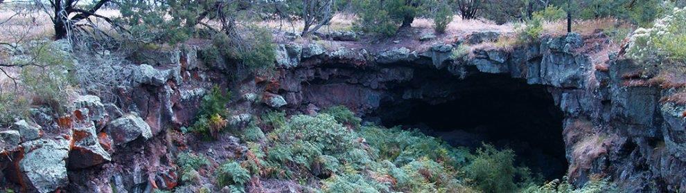
Byaduk Caves
The Byaduk Caves in Mt Napier State Park are the most extensive and accessible set of lava caves in Australia. Being so young ( only 8,000 years), they are largely unweathered and in their natural state. The caves are accessed through collapsed roof sections and display many well-preserved features left by the retreating and cooling lava. The largest tunnels are up to 18 metres wide, 10 metres high, and extend to depths of 20 metres below the surface.
Mt Napier
Approximately 20 km south of Hamilton lies Mt Napier, the youngest volcano in Victoria and the highest volcanic point in the Western District Plains, with many eruption and lava flow features that are remnants from the last stages of volcanic activity 10,000 years ago. Some lava flows reach as far as the sea between Port Fairy and Portland. Mount Napier is best attempted with a 4WD. There are a number of dry stone wall sites around Mt Napier State Park.
Penshurst Volcanoes Discovery Centre and Mt Rouse
The Penshurst Volcanoes Discovery Centre provides an insight into all types of volcano’s with specific information about Australia’s most recent volcano’s found along the Kanawinka Geotrail. Mt Rouse is a massive accumulation of scoria, with several craters, rising 100 metres above the surrounding volcanic plain and is an excellent vantage point to view the adjacent volcanoes of Mt Eccles and Mt Napier.
Mt Eccles/Budj Bim Lava Flow/Lake Condah
Budj Bim is the name given to Mt Eccles by the Gunditjmara indigenous traditional owners, whose ancestors saw it beginning around 20,000-30,000 years ago. Large wetlands were created form the lava flows which formed Lake Condah, where the local Gunditjmara harvested eels and fish, using the stones to construct elaborate channels, weirs, fish traps, wind breaks and stone huts.It is an area of local and national significance as it is considered to be Australia’s earliest and largest aquaculture venture and the only place in Australia where indigenous people built permanent housing. The Budj Bim National Heritage Landscape was National Heritage Listed in 2004 .
Lady Julia Percy Island
Lady Julia Percy Island, located just of the coast from Port Fairy, is a low flat island built of submarine basalt flows up to 7.8 million years old. This is the only major basalt island of the western Victorian coast, and the island is home to mutton-bird colonies, fairy penguins,lizards sea birds, crayfish, sharks and 23,000 Australian fur seals, the largest colony in the southern hemisphere.
Tower Hill and Interpretive Centre
Tower Hill Game Reserve, 15 km west of Warrnambool features a deep circular crater formed some 25,000 years ago and is one of the largest maars in the world, formed when a hot rising basaltic magma came into contact with the subterranean water table. The violent explosion that followed created a funnel shaped crated which later filled with water to form a lake and the islands that can be observed today. The Worn Gundidj Aboriginal Cooperative run an Interpretation Centre within the crater which displays the history of this complex maar volcano and provides fascinating guided walks.
Hopkins Falls
The Hopkins River pours over a beautiful basalt escarpment at Wangoom. In winter ans spring the viewing is spectacular. For a couple of weeks in the late summer it is sometimes possible to see baby eels climbing the falls.
Lakes and Craters Precinct
Towns of the Lakes and Craters Precinct include; Colac, Camperdown, Lismore, Derrinallum, Terang, Skipton, Mortlake, Lake Bolac, Darlington.
Points of Interest
Mt Noorat
Mt Noorat is named after local aboriginal elder Ngoora and was a traditional meeting and bartering place for the Kirrae Wuurong people. It is a scoria cone with complex eruption point topography, and its central feature is an entire circular crater.
Mt Shadwell
Mt Shadwell is a scoria cone with a commercial quarry. Within the quarry it is possible to fossick for olivine, a pale green crystal found in volcanic “bombs” thrown out during violent volcanic eruptions.
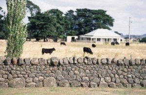
Lake Keilambete
Lake Keilambete is a near perfectly circular lake of national significance. The very saline water is reputed to have therapeutic value.
Lake Bullen Merri
Lake Bullen Merri is a 490 ha lake enclosed in a volcanic crater located on the outskirts of Camperdown. A large complex multiple maar, the lake system is of international significance and has a richly documented Aboriginal Heritage.
Lake Gnotuk
Lake Gnotuk has formed in a single maar crater. Maar lakes such as this rely on ground water seeping into the lake and have no outlet. And a result evaporation has caused Lake Gnotuk to become twice as salty as sea water.
Mt Leura
Mt Leura is a beautiful cone and maar system, part of a large volcanic complex. From the top there are excellent views across the volcano’s of the whole eastern Kanawinka Geotrail landscape.
Mt Sugarloaf
Mt Sugarloaf is a steep conical accumulation of scoria rising as a high point on the same crater rim as Mt Leura. It formed as a result of lava fountaining from the same point in the crater. building an ever increasing pile of scoria.
Lake Purrumbete
Lake Purrumbete is a large maar lake which contains a fresh water lake around 22 m deep. It is a highly regarded fresh water fishing spot and is stacked with rainbow and brown trout and chinook salmon.
Mt Porndon
Almost a perfect cone, Mt Porndon rises from a complex of lava flows, tuff deposits, scoria cones and craters. Several basalt flows are evident and the youngest of these flows has formed a lava disc, roughly 3 km in diametrer with a rocky wall between 10 and 15 m in height. This lava disc is the largest of its kind in Australia. The centre of Mt Porndon is around 15 m deep and is open to the west.
Stony Rises
One of the most prominent stony rise in Victoria, the area is charicterised by ts rocky and undulating landscape. Ridges and depressions up to 15 metres high or deep formed when liquid lava broke through the hardened outer skin of molten lava, the outer skin then sagged and collapsed. Areas of peat bogs, formed in the depressions over thousands of years, small swamps and wetlands combine to make this an amazing and diverse landscape.
Lake Bolac and Mt Wyvern
Lake Bolac was formed when Mt Wyvern, a very low lava cone just to the south, blocked the local streams about 1 million years ago. The town is famous for an annual Eel festival associated with the lake.
Mt Hamilton
Mt Hamilton is a very good example of tertiary basalt cone with enclosed crater and features three lava caves with unusual branching passages. Its eruption diverted Fiery Creek westwards into Lake Bolac. Mt Hamilton is on private property.
Mt Widderin
Mt Widderin is a broad low dome with lava flows and stony rises to the south and west where details are observable in road cuttings. This private property features a sizable 2 chamber lava cave with a rich local history which is open 1 day a year for local project fundraising.
Mt Elephant
Mt Elephant is one of the most prominent volcano’s in Australia, and is often referred to as the “swag-man’s lighthouse” of Victoria’s western district. It is listed on the Register of the National Estate by the National Trust of Australia as ” one of the highest and one of the most major scoria cones in the largest homogeneous volcanic plains on earth”
Lake Corangamite
Lake Corangamite RAMSAR listed and Victoria’s largest inland lake, has a surface area of 234 square km and a circumference of about 150 km, stretching north- south for 32 km. Normal salinity is saltier than the sea but in dry conditions, the water become hyper saline. Even in this state, masses of brine shrimp survive and provide food for seasonal water birds.
Red Rock
Over 40 eruption points have been determined in the internationally significant Red Rock volcanic complex. There are 7 major crater lakes within the scoria cones. Red Rock lookout, near Alvri, north of Colac, provides 360 – degree views of other volcanic features, including Mts Elephant, Porndon and Sugarloaf, and Lake Corangamite.
Floating Islands
Water has partly – filled a series of collapsed lava flows in “stony rise” country. Peat masses drift with the wind across the small lakes in the wet seasons. The area has many dry stone walls constructed by early settlers.
Lakes Colac, Bookar and Tooliarook
Many lakes in this vicinity occupy shallow craters or wetlands created by lava flow diversions and blockages. Lake Bookar is a RAMSAR listed site renowned for bird life while Lakes Colac and Tooliarook are popular for boating and fishing.
Dry Stone Walls
The western plains of Victoria are among the world’s greatest basalt plains, where the many lava flows have weathered into broken volcanic stone fields. Using these, early settlers from England, Scotland and Ireland built many dry stone walls in the mid nineteenth century for crops, livestock, to contain rabbit plagues and for protection against fire. Corangimite Arts have established the Corangimite Dry Stone Walls heritage Trail and their brochure covers 10 sections of the most diverse and significant walls in the precinct, including Kolora to the west near Mt Noorat, to the west of Mt Elephant near Derrinallum and at Pombornelt amongst the Stony Rises.
Lake Terang
Lake Terang is a dry Crater Lake of State significance. encircled by a walking track.
Craters and Limestone Precinct
Towns of the Craters and Limestone Precinct include; Mount Gambier, Millicent, Penola, Port MacDonnell, Coonawarra, Allendale East, Tantanoola, Glencoe, Mount Burr, Carpenter Rocks, and Beachport
Mt Burr Range
Mt Burr Range contains 15 volcanic eruption points, and is much older than te near by Mt Gambier and Mt Shank, ranging from 20,000 to two million years old. The Booandik Aboriginal people of this region hold the memory of the eruption in their legend of a great ancestor. Craitbul, who fled from the Mt Burr area only to have his ovens extinguished by the rising groundwater’s four times, (the four craters near Mt Gambier) Mt Muirhead was another oven of the giant.
Mt Muirhead
Spectacular views can be obtained from the lookout opposite Mt Muirhead located approximately 6km from Millicent where you can see across to the town and further south to the Canunda National Park and extensive wind farms. Mt Muirhead is privately owner and public access is not permitted.
Mt McIntyre
Located 20 km from Millicent is another member of the Mt Burr Group. Bush walkers, cyclists and horse riders use the forest roads and track network extensively. Permits are required for horse riding, caving, wildlife studies and firewood collection. There are a number of beautiful picnic spots in the forest, but camping is not permitted. Roads may not be suitable for all vehicles.
Lake Leake
Lake Leake features a wide, open crater with a low, gently sloping ash ring, and is open to the public all year round. Fishing, boating, windsurfing,power boating and water skiing are permitted. There are boat launching facilities and it is used by an Aquatic Club from time to time for races.
Lake Edward
Lake Edward is a volcanic lake where the crust has cracked open and been tilted leaving bulbous lobes of lava that were squeezed out of the cracks. Lake Edward is set amongst the gum plantations, pine forests and re-vegetated areas with a boardwalk and panoramic views, ideal to view bird life and enjoy a picnic.
Tantanoola Cave
A single chamber cave, Known for its scenic beauty, pink dolomite caverns and an array of unusual speleothems. it has comfortable wheelchair access for visitors.
Coonawarra
Coonawarra is an aboriginal word meaning “Honeysuckle”. It is renown as one of Australia’s finest wine regions and is especially known for producing world class red wines, especially Cabernet Sauvignon. Its secret lies in a magical marriage of rich terra rossa soil, limestone, pure underground water and a long cool ripening season for the grapes.
Canunda National Park
Canunda is a large region of high coastal dunes built up on the limestone plains by the relentless power of the Southern Ocean. Protected behind the dunes is Lake Bonney, South Australia’s largest fresh water lake .Canunda is 4WD access only onto the vast sandy ocean beaches.
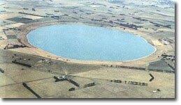
Mount Gambier Blue Lake and Valley Lakes Complex
This volcanic area, estimated to have been formed some 28,000 years ago over two closely spaced periods,incorporates Blue Lake,Valley Lake, Browne’s Lake and Leg of Mutton Lake. The Blue Lake is world famous due to its unique color change from somber winter steel grey to brilliant turquoise blue between November and March each year. It is also the source of water for the City of Mt Gambier which flanks the volcanic crater. Start at the Blue Lake Reception Centre where interpretive signage describes the features of the Mount Gambier Crater Lakes Complex. The 3.6 km road and walking track around the circumference provides access to many marvelous views. It is a popular place for all ages with its picnic areas and undercover shelters, free barbecues, adventure playground and the Valley Lake Wildlife Park and Boardwalk which is also free of charge and open to dusk each day.
Engelberch Cave
This complex limestone cave runs under the city itself and was first explored around 1884. Highly trained cave divers regularly explore this extensive wet cave system which has hidden water-filled chambers under the city.
Cave Gardens
State Heritage Area situated in the centre of the city, this sinkhole was the original source of water supply for the early settlers. Famous for its roses, the Cave Garden is a great place for a picnic. Its beauty and significance can be appreciated from the viewing area whilst experiencing the free nightly sound and light show.
Umpherston Sink Hole
The sink hole was created when the top of the chamber fell to the floor of the cave, creating the perfect environment for its “sunken garden” and resident possums who venture out at dark.
Mt Shank
Mt Shank located 10 minutes drive south of Mt Gambier is considered to be the youngest volcano in Australia (6,000 years). Protruding 159 metres above sea level, it is very prominent above the limestone plain. Interpretive signage explains the volcanic significance of this site and provides information on the two adventurous walks , one to the top of the volcano, the other descending steeply to the volcano floor. The rim offers fantastic views of the surrounding limestone plains, coast and the nearby volcanic formations, lava flows and a small cone on the southern side which is believed to have been formed as the first stage.
Ewans Ponds
Ewans Ponds Conservation Park incorporates a small bush land park and the 3 ponds which feed Eight Mile Creek.Snorkel or dive the underwater gardens to explore the fascinating springs which bubble up through the limestone at the bottom of the ponds.
Piccaninnie Ponds
Snorkel, walk, camp or observe the natural wonder of Picaninnie Ponds Conservation Park, where the crystal clear water makes its way to the surface after filtering slowly underground through a 100 meter deep limestone canyon. A world renown cave diving site ( permits are available to certified divers only).
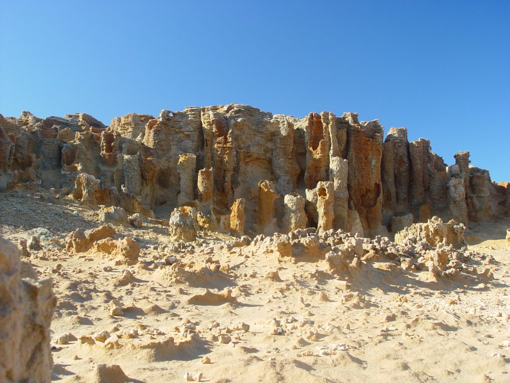
Woakwine Cutting
A series of ancient parallel dune limestone ranges were left by the sea’s retreat over the last million years. Woakwine Dune was cut to drain the swamp lands behind it and the deep cutting reveals the complex layering within the 300,000- year old dune.
Beachport
Featuring the Pool of Siloam and one of South Australia’s longest jetties. Beachport is a haven sheltered behind rugged extensive limestone cliffs pounded by the Southern Ocean.
Cape Northunberland
Ruins of a historic lighthouse rest above dramatic eroded limestone cliffs with exposed strata and which shelter a penguin colony. Sweeping views show where the pounding sea has shaped Frog Rock, Camel Rock and Rhino Rock above extensive limestone reefs.
Plateaus and Falls Precinct
Towns of the Plateaus and Falls Precinct include; Casterton, Coleraine and Hamilton
Dundas Tablelands
3 sweeping views across the Dundas Tablelands above Casterton at Mackwoods Lake Lookout and along the road near Coleraine show where the Wannon River has cut deeply into the iron-stone capped Tablelands, forming high, wide plateaus, which drop away to the south and west along the Kanawinka Fault.
The Points Arboretum
Located at Coleraine, this contains over 10,000 plants including 63 rare and endangered species. Its Eucalypt collection is a renowned botanical reference for the native vegetation that compliments the Kanawinka region’s geology and soils.
Wannon Falls
The Wannon Falls were created by lava flows that surged upstream to the Wannon River. The water which cascades over a 30 metre vertical precipice into a deep plunge pool below, is actually flowing over hardened basalt lava. Further down stream rapids wind their way around large blocks of basalt,disgorged over time down the embankments of the narrow valley. A cantilevered viewing platform at Wannon Falls offers, spectacular views. A nearby rotunda features interpretive signage for visitors, covering geology, flora & fauna, Koori history and details of colonial artists who painted the area. Camping facilities are available at Wannon Falls.
Nigretta Falls
It is thought that the site where the Nigretta Falls are formed may have been the location of a super volcano about 450 million years ago. It has excellent river walks, viewing areas, barbecue facilities, red gum picnic tables and a jarrah stairway leading to the base of the falls.
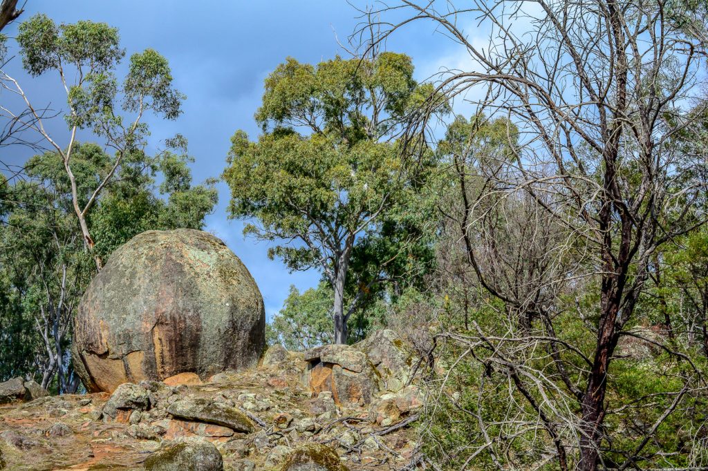
Baileys Rocks
Baileys Rocks are an unusual group of Green colored granite boulders which are part of a long series of outcrops through the Dundas Tablelands & the Padthaway Ridge to the west. They formed before the separation of Australia form Antarctica. Enjoy an Aussie lunch at “The Pub in the Bush” at Dergholm.
Giant Rock
Giant Rock extruded through the Dundas crust as a huge volcanic plug of altered trachyte of the Jurassic Coleraine Volcanic Group. It formed from magma which cooled slowly deep in the crust and contains many small crystal grains. It is on private property but can be viewed via a 1 km walking trail available to the public. A much smaller plug is along the road near by.
Caves and Coast Precinct
Towns of the Caves and Coast Precinct include; Portland, Nelson, Dartmoor, Cape Bridgewater and Heywood.
Princess Margaret Rose Cave
One of the many limestone caves in the Lower Glenelg National Park, the Princess Margaret Rose Cave is the most attractive and is the only cave suitable for public use. It contains excellent examples of actively growing stalactites, stalegmits,helictites and other spectacular limestone formations, all contained within an elegant vertical rift which cuts across a large bend of the Glenelg River. You can take a beautiful river gorge cruise to the cave and have lunch amongst the kangaroos of the forest in its natural habitat. THE CAVE IS CURRENTLY CLOSED TO THE PUBLIC FOR VIEWING
Glenelg River Gorge
The Glenelg River rises in the Grampians and winds 400 km to the sea, Over its last 15 km carving a 50 m deep spectacular gorge through limestone. The river offers excellent opportunities for flat water canoeing over the 75 km from Dartmoor to its mouth near Nelson. For much of this distance, the river flows through the Lower Glenelg National Park, enabling water enthusiasts to observe wildlife in its natural habitat. A river cruise is available from Nelson near the river mouth, travelling upstream between the cliffs of the limestone gorge which was cut downwards by the river as a broad limestone plain was slowly uplifted by regional forces of very deep magma beneath. Sail past Donovans Landing and the Isle of Bags. The fishing town of Nelson is a delightful place to relax and watch the life of the river where it meets the estuary.
Cape Bridgewater and Bridgewater Bay
Situated 18 km from Portland and overlooking the beautiful Bridgewater Bay was once a volcanic island. About 8,000 years ago, rising sea levels built a ridge of sand dunes between Cape Bridgewater Volcanic Island and the mainland. Over time, rainfall and ground water have hardened these into dunes of sandy limestone. Bridgewater Bay is such a long and beautifully curved ocean beach that it is often photographed for commercials from the sweeping lookout. A five kilometre walking trail takes the visitor to Victoria’s highest sea cliff. Cape Bridgewater itself where a platform looks down on a seal colony in the large sea cave below and across to the solid buttress of Cape Nelson. The walk continues along dark basalt cliffs to the Blowholes at Cape Duquesne and can be walked in either direction.
Tarragal Caves & Mt Richmond
Tarragal Caves are undercuts in ancient dune limestone with spectacular views overlooking Cape Duquesne, the Bridgewater Lakes and Discovery Bay, areas also noted for ancient aboriginal middens. An extinct volcano surrounded by low flat land Mt Richmond consists not of basalt but of porous rock called tuff, which was formed when the volcanic ash gradually hardened over two million years ago. Apart from the occasional outcrops of basalt near the summit , the volcanic geology is almost entirely buried by dune limestone and sand blown inland long ago from Discovery Bay. Noted for its flora and fauna, the peak is covered with forest,open heath and scattered swamps. Various walks and picnic areas are available.
Petrified Forest
A walk from the Blowholes leads past the “Petrified Forest” which is thought to have developed when a Moonah forest was smothered by a large sand dune, creating unusual sandstone formations around the decaying tree trunks.
Cape Nelson, Yellow Rock and Lawrence Rocks
Large basalt flows have formed the base of the Cape and Island, which are both capped by wind blown sands now hardened into Limestone sheets. The bay itself is actually a field of volcanic cones and craters now submerged by the sea. There are three lookouts around the bay, starting from the lighthouse. The white cover of Lawrence Rocks is actually a huge colony of yellow headed gannetts, safe on top of the island. Now well protected they have also colonised Cape Grant on the mainland opposite.
The Kanawinka Fault
The large Kanawinka Fault runs for over 100 km across the Geotrail and gives it its name. It can be seen along the Greenwald/ Winnap road at Keegan’s Bend lookout and at Hedditch Hill where the volcanic uplands of the east drop away to the vast limestone and dune plains to the west.